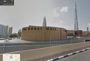

Google Street View makes Arab debut in Dubai

Hotels, malls and major attractions are among the aspects of Dubai people around the world can now explore using Google Street View, after the city became the first in the Middle East to be included on the service.
Since yesterday (December 8), Google Maps users have been able to explore many of the city’s main key roads with street-level, panoramic and 360-degree views.
Writing on an official company blog, Mohamad Mourad, regional director for Google, Middle East and North Africa, said: “It’s hard to believe that a city not much larger than 4,000 square kilometers has become such a hub of modern culture with more than 200 nationalities mingling daily, as well as a center for trade and tourism in just four short decades.
“We hope that you’ll be inspired to explore its wonders in person, but until then, they’re just a click away.”
At present, the service does not appear to map out many residential areas, in contrast to major cities in Europe and North America, where almost every street is often included.
Google captures the street-level images with a network of cars, with cameras mounted on them, going around the cities.
It has also used cameras mounted on bicycles and even backpacks to collect imagery for places which are harder to reach.
Number plates and people’s faces are generally obscured on the Street View service.